MORE 'MAPS' POSTS
OCLC Officially Announces the Launch of a “Redesigned and Reimagined” WorldCat.org
| Academic Libraries, Associations and Organizations, Companies (Publishers/Vendors), Libraries, Maps, News, Patrons and Users, Public Libraries
Update: OCLC has posted two announcements about today’s release of the new WorldCat.org. Both are posted and linked below. The first release targets library users. After that, you’ll find a release aimed at the library/librarian community. Finally, at the very bottom of this post you’ll find a video tour of the new WorldCat.org that was […]
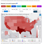
From a NOAA News Release: A comprehensive update to NOAA’s Billion Dollar Disasters mapping tool now includes U.S. census tract data – providing many users with local community-level awareness of hazard risk, exposure and vulnerability across more than 100 combinations of weather and climate hazards. The enhanced interactive maps from NOAA’s National Centers for Environmental […]
Research Tools: New Interactive Map and Timeline Added to Chronicling America
| Data Files, Digital Collections, Interactive Tools, Libraries, Maps, News, Patrons and Users
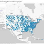
From the Headlines and Heroes Blog/Library of Congress: Chronicling America* users can now browse the collection’s thousands of digitized historical newspapers using an interactive map and timeline recently launched by the Library of Congress. The new “Exploring Chronicling America Newspapers” application dynamically maps publication locations of over 3,000 digitized newspapers currently available in the Chronicling […]
scite Partners With Springer Nature for Pilot on Research Solutions Hub and More News Headlines
| Associations and Organizations, Maps, News, Springer Nature

Announcing SPARC’s Knowledge Equity Discussion Series How AI Could Help Make Wikipedia Entries More Accurate (via Meta) Now Available: Recording and Slides for IFLA ARL Webinar Re: Research Ethics scite Partners With Springer Nature for Pilot on Research Solutions Hub Scopus Now Includes Preprint Content From Two Additional Preprint Servers: TechRxiv and Research Square Technology […]
“Research Integrity: Creating and Supporting Trust in Research” is 2022 Peer Review Week Theme & More News Headlines
| Data Files, Maps, News
Apple Maps Gets More Detailed 3D Data for Three More Countries (via Apple Insider) Celebrating the United States’ 40 Millionth Copyright Registration (via USCO) DOAJ Freezes Supporter Rates for 2023 (via DOAJ) Improving Equity, Diversity, and Inclusion in Academia (via Research Integrity and Peer Review) “Research Integrity: Creating and Supporting Trust in Research” is 2022 […]
Research Tools: US Census Releases Major Updates to “My Community Explorer”
| Data Files, Interactive Tools, Maps, News, Patrons and Users
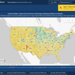
From the US Census: Today the U.S. Census Bureau announced the release of major updates to the data explorer tool, My Community Explorer (MCE). MCE is an interactive, map-based tool that highlights demographic and socioeconomic data. These data measure inequality and help inform data-based solutions. This tool is designed to help users identify underserved communities […]
From Fast Company: A new tool from Google Earth Engine and the nonprofit World Resources Institute pulls from satellite data to build detailed maps in near real time. Called Dynamic World, it zooms in on the planet in 10-by-10-meter squares from satellite images collected every two to five days. The program uses artificial intelligence to […]
New “Lost Voices” Online Exhibit Translates and Digitizes America’s Oldest Parish Archive to Provide Rare Insight Into Early Florida History
| Archives and Special Collections, Digital Collections, Funding, Maps, News, Patrons and Users
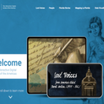
From the University of South Florida: A new online exhibit launched today by La Florida: The Interactive Digital Archives of the Americas will provide the public with unprecedented insight into the daily lives and relationships of the multi-ethnic population that comprised St. Augustine, Fla. from the 16th-19th centuries. The Florida city is the oldest continuously […]
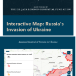
From an ISW E-Mail: ISW is launching a new Interactive Map of the Ukraine War to provide an accessible tool for understanding Ukraine’s fight against the Russian invasion. ISW’s interactive map will serve as an analog to the static Ukraine maps that ISW currently produces and disseminates daily. Where possible, the interactive version enables high-fidelity […]
Northwestern University, University of British Columbia, and DB Ecosensystem Join the IIIF; Consortium Now at 63 Members
| Data Files, Digital Collections, Interactive Tools, Libraries, Maps, News, Preservation, Publishing

From an International Image Interoperability Framework (IIIF) Announcement: We are happy to announce that Northwestern University Libraries have joined the IIIF Consortium as a full member, along with the University of British Columbia (UBC) Library and DB Ecosensystem joining as associate members. This bring the total number of consortium members to 63. The Northwestern University […]
