Research Resources: NOAA Releases a Comprehensive Update to Billion Dollar Disasters Mapping Tool
From a NOAA News Release:
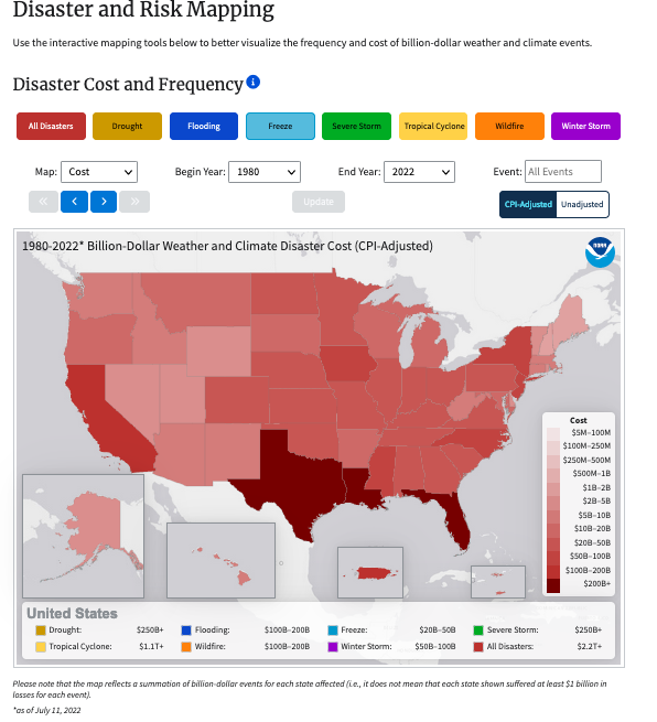
A comprehensive update to NOAA’s Billion Dollar Disasters mapping tool now includes U.S. census tract data – providing many users with local community-level awareness of hazard risk, exposure and vulnerability across more than 100 combinations of weather and climate hazards.
The enhanced interactive maps from NOAA’s National Centers for Environmental Information (NCEI) cover all 50 states and the District of Columbia, and provide data for over 72,000 U.S. census tracts, which are small subdivisions of counties that average about 4,000 inhabitants. Users can now visualize a community’s combined physical exposure, socioeconomic vulnerability and markers of resilience to natural hazards on a finer scale than ever before.
[Clip]
The census tract data builds on county-level data added to the mapping tool last year. The weather and climate hazards displayed through the tool include severe storms and tornadoes; drought events and heat waves; hurricanes and tropical storms; wildfires; river-basin and urban flooding; and winter storms, freeze events and cold waves.
Direct to Interactive Enhanced State and County-Level Maps
Direct to Complete NOAA’s Billion-Dollar Disasters Website (Mutiple Online Data Tools)
Filed under: Data Files, Maps, News, Patrons and Users
About Gary Price
Gary Price (gprice@gmail.com) is a librarian, writer, consultant, and frequent conference speaker based in the Washington D.C. metro area. He earned his MLIS degree from Wayne State University in Detroit. Price has won several awards including the SLA Innovations in Technology Award and Alumnus of the Year from the Wayne St. University Library and Information Science Program. From 2006-2009 he was Director of Online Information Services at Ask.com.


