MORE 'MAPS' POSTS
Urban Libraries Council Names 2023 Top Innovators
| Awards, Data Files, Funding, Libraries, Management and Leadership, Maps, News, Public Libraries

From a ULC Announcement: Today, the Urban Libraries Council (ULC) recognized 16 North American public libraries as Top Innovators for transformative programs that enhance the library field to further equity, education and civic engagement for all. ULC announced the 2023 Top Innovators and Honorable Mentions during the live, virtual 2023 Innovations Celebration on April 27, […]
Wisconsin: Explore Transportation History With WisDOT’s New Online Highway Map Archive
| Data Files, Maps, News
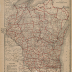
From the Wisconsin Dept. of Transportation: The Wisconsin Department of Transportation (WisDOT) today released an online archive of Wisconsin’s Official State Highway Map over the past 100 years. The first edition of the state highway map was printed in 1918 for public distribution. Since then, Wisconsin residents and visitors reference the highway maps to reach […]
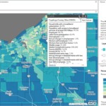
From the U.S. Census: The U.S. Census Bureau, in partnership with the National Telecommunications and Information Administration (NTIA), today announced the launch of the ACCESS BROADBAND Dashboard. ACCESS BROADBAND stands for Advancing Critical Connectivity Expands Service, Small Business Resources, Opportunities, Access, and Data Based on Assessed Need and Demand Act. The new data tool shows how […]

From an ISW E-Mail: ISW has updated and enhanced its interactive time-lapse map of assessed control-of-terrain in Ukraine to mark the one-year anniversary of Russia’s full-scale invasion. Time-lapse maps for specific months are available via the links below and include new interactive features such as a search function, a measuring tool, and changeable base maps. Also Available Monthly […]
Research Tools: EveryLibrary Institute Releases Interactive Map of School Librarian Requirements and Outcomes by State
| Data Files, Libraries, Management and Leadership, Maps, News, Open Access, School Libraries
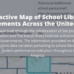
From the EveryLibrary Institute Release Announcement: The EveryLibrary Institute is excited to provide public access to the San Jose State University iSchool’s interactive map to help researchers and job searchers understand the requirements to become a school librarian in each state. The project also includes data from the SLIDE Project regarding school library/librarian ratios by state and as well […]
Library of Congress: Announcing LC Labs Data Sandbox and 3 New Data Packages
| Data Files, Digital Collections, Interactive Tools, Libraries, Maps, News, Open Access
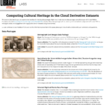
From a Library of Congress Blog Post by Eileen J. Manchester: LC Labs is pleased to announce the release of three new sets of digitized materials packaged as data. Located on data.labs.loc.gov, the three data packages of digitized maps, books, and photographs respectively, were created as part of the Computing Cultural Heritage in the Cloud (CCHC) initiative’s investigation […]
Building Digital Research Tools for Open Access to Canada’s Historical Topographic Maps and More News Headlines
| Data Files, Libraries, Maps, News, Open Access

Building Digital Research Tools for Open Access to Canada’s Historical Topographic Maps and Data (via University of Toronto Libraries) Newark Black Newspapers Collection Now Available Online (via Rutgers University Libraries)
Maps: Three New Series Relating to Puerto Rico Fully Digitized and Available Online From NARA
| Archives and Special Collections, Management and Leadership, Maps, News
From The Unwritten Record (A National Archives and Records Administration Blog) by Amy H. Edwards: The Cartographic Branch is pleased to announce that three new series of records relating to Puerto Rico have been fully digitized and are now available online for viewing and download through the National Archives Catalog. The first series, RG 95: […]
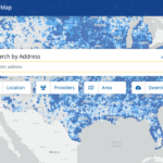
From the Federal Communications Commission: The Federal Communications Commission today released a pre-production draft of its new National Broadband Map. The map will display specific location-level information about broadband services available throughout the country – a significant step forward from the census block level data previously collected. This release of the draft map kicks off […]
Data Tools: USGS Launches Wildland Fire Trends Tool
| Data Files, Management and Leadership, Maps, News, Patrons and Users
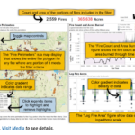
From the US Geological Survey: A team of scientists from the Forest and Rangeland Ecosystem Science Center created the Wildland Fire Trends Tool (WFTT), a data visualization and analysis tool that calculates and displays wildfire trends and patterns for the western U.S. based on user-defined regions of interest, time periods, and ecosystem types. Users can use […]
