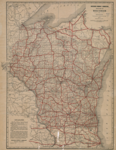
The Wisconsin Department of Transportation (WisDOT) today released an online archive of Wisconsin’s Official State Highway Map over the past 100 years. The first edition of the state highway map was printed in 1918 for public distribution. Since then, Wisconsin residents and visitors reference the highway maps to reach their destination or simply explore the wonders across the state.
[Clip]
The first few map publications in the 1920s served as a guide of the state trunk network and sold for 10 cents per copy. By the 1930s, maps were distributed for free to the public with a new emphasis on road safety. The maps also promoted travel and tourism for residents and visitors to enjoy the great amenities across Wisconsin. Tourism promotion included catchy themes and slogans, governor’s welcome messages, photos and engaging advertisements. Today’s map includes the highway map data and creative content developed by WisDOT and the Wisconsin Department of Tourism.
Gary Price (gprice@gmail.com) is a librarian, writer, consultant, and frequent conference speaker based in the Washington D.C. metro area.
He earned his MLIS degree from Wayne State University in Detroit.
Price has won several awards including the SLA Innovations in Technology Award and Alumnus of the Year from the Wayne St. University Library and Information Science Program. From 2006-2009 he was Director of Online Information Services at Ask.com.