MORE 'MAPS' POSTS
University of Illinois: Information Sciences Professor Developing Tool to Make Data Visualizations Accessible to Blind Researchers, Students
| Data Files, Maps, News

From the University of Illinois: JooYoung Seo, a professor of information sciences at the University of Illinois Urbana-Champaign, is developing a data visualization tool that will help make visual representations of statistical data accessible to researchers and students who are blind or visually impaired. The multimodal representation tool is aimed at the accessibility of statistical graphs, such […]

From MLive.com: Tucked away on the upper floors of the Library of Michigan, the rare book vault is about 60 degrees with very low humidity. It’s not too cold, but compared to the mild temperatures throughout the rest of the library, the drop is noticeable. Randy Riley, state librarian for the Library of Michigan, jokes […]
Reclaim The Records Announces Launch of The Connecticut Genealogy Index, More than 5.5 Million Records Available
| Data Files, Maps, News, Publishing
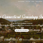
From a Reclaim The Records Blog Post: Introducing ConnecticutGenealogy.org! It’s a FREE searchable database of 576,638 births, 2,180,700 marriages, 2,086 civil unions, and 2,772,116 deaths from the state of Connecticut, spanning three centuries. Some of this data had been online before, scattered across several other websites, but with fewer years, in non-downloadable and non-shareable formats, locked behind […]
National Endowment For the Humanities (NEH) Announces $41.3 Million For 280 Humanities Projects Nationwide
| Awards, Digital Preservation, Funding, Interviews, Journal Articles, Libraries, Maps, News, Podcasts, Preservation

From the National Endowment For the Humanities: The National Endowment for the Humanities (NEH) today announced $41.3 million in grants for 280 humanities projects across the country. These grants will support a documentary by acclaimed filmmaker Stanley Nelson on the life, work, and legacy of jazz legend Sun Ra; the creation of a set of linked […]
New AI-Powered Tools From Dimensions (Beta Release) & Scopus (Alpha Release) Launching Today
| Associations and Organizations, Companies (Publishers/Vendors), Data Files, Elsevier, Funding, Maps, News, Patrons and Users, Profiles
UPDATE 8/2: ChatGPT Like AIs are Coming to Major Science Search Engines (by Richard Van Noorden via Nature) —End Update— Two announcements today. Highlights from both + links below. 1. Powering Research with Dimensions AI Assistant Dimensions is introducing the beta of a new AI Assistant to enhance the user experience, with the research community […]
Newly Launched Resource: Introducing texas.dp.la – a Digital Public Library of America TxHub Site
| Archives and Special Collections, Digital Collections, Interactive Tools, Libraries, Maps, News, Public Libraries
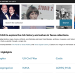
From a Texas Digital Public Library Post: As many of you are aware, TxHub is the DPLA Service Hub of Texas, providing metadata for thousands of cultural heritage items to the Digital Public Library of America. DPLA makes those items, and millions of others across the country through the web portal and its open API. TXHub […]
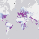
From the MS Bing Blogs: Microsoft Maps has a dedicated Maps AI (artificial intelligence) team that has been taking advantage of Microsoft’s investments in deep learning, computer vision, and ML (machine learning). Applying all that cool tech to mapping has yielded many useful datasets and our latest worldwide dataset includes a whopping 1.2B building footprints and 174M building […]
Yale Launches LUX, A Powerful New Search Tool For Cross-Collection Exploration
| Academic Libraries, Archives and Special Collections, Associations and Organizations, Journal Articles, Libraries, Maps, News, Patrons and Users
From the Yale Library: LUX: Collection Discovery—a new cross-collection search tool—provides users worldwide with online access to more than 17 million items within Yale University’s museums, libraries, and archives. “The LUX project is an incredible way to bring together the diverse collections across the cultural heritage units at Yale,” said Barbara Rockenbach, Stephen F. Gates […]
Hong Kong Public Libraries Pull Most Books Related To Tiananmen Square Crackdown as 34th Anniversary Approaches; IIIF Consortium Announces New Extensions For Working With Digitized Maps; & More News Headlines
| Archives and Special Collections, Awards, Elsevier, Libraries, Maps, News, Public Libraries
Hong Kong Public Libraries Pull Most Books Related to Tiananmen Square Crackdown as 34th Anniversary Approaches (via SCMP) IIIF Consortium Announces New Extensions For Working With Digitized Maps (via IIIF) Texas: Ransomware Attack Has Dallas Library Telling Residents to Keep Overdue Books (via DMN) Library of Congress: Connecting Communities Digital Initiative Announces Next Round of […]
Digital Collections: Library of Congress Completes Digitization of Yongle Encyclopedia, Largest Reference Work of Pre-Modern Era
| Digital Collections, Digital Preservation, Interactive Tools, Libraries, Maps, News, Open Access, Preservation, Reports

From the Library of Congress: The Library of Congress has completed a yearslong effort to digitize the Yongle Encyclopedia (Yongle dadian 永樂大典), the largest reference work created in pre-modern China, and possibly the world. Digital publication of the 41 volumes held in the Library’s collections provides open access to one of the most extensive attempts in world […]
