Research Tools: US Census Releases Major Updates to “My Community Explorer”
From the US Census:
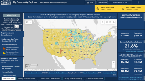
Today the U.S. Census Bureau announced the release of major updates to the data explorer tool, My Community Explorer (MCE). MCE is an interactive, map-based tool that highlights demographic and socioeconomic data. These data measure inequality and help inform data-based solutions. This tool is designed to help users identify underserved communities as directed by the President’s Executive Order 13985 on Diversity, Equity, Inclusion, and Accessibility in the Federal Workforce.
Among the updates:
- NEW Live Feeds from ArcGIS Living Atlas of the World for Wildfires, Hurricanes, and AirNow Air Quality Monitoring have been added to the interactive map as visuals that can be overlaid on census data. Visit the links to learn more about data sources and update frequency.
- Changes to map labeling, aggregation of map pop-ups and a move from a side-by-side map comparison to one map.
- Legend has been moved into a collapsed legend within the map to accommodate new layers.
- Clarified labeling and instructions for the Community Context panel and for generating a County Profile.
- Added links to access the Data Services used in the MCE.
- Added release notes window within the tool.
In addition to the updates, data from Phase 8 of the Small Business Pulse Survey are now available. A new training video will also be released in July.
Filed under: Data Files, Interactive Tools, Maps, News, Patrons and Users
About Gary Price
Gary Price (gprice@gmail.com) is a librarian, writer, consultant, and frequent conference speaker based in the Washington D.C. metro area. He earned his MLIS degree from Wayne State University in Detroit. Price has won several awards including the SLA Innovations in Technology Award and Alumnus of the Year from the Wayne St. University Library and Information Science Program. From 2006-2009 he was Director of Online Information Services at Ask.com.


