Research Tools: “Mapping our Global Human Footprint” (World Settlement Footprint 2015)
From the European Space Agency:
The number of people flocking to cities in search of employment and better prospects is growing at an unprecedented rate. By 2050, the global population is estimated to reach nine billion, 70% of which will be living in urban areas. The World Settlement Footprint 2015 (WSF-2015) is the first map, using mass collections of radar and optical satellite imagery, to provide a global overview of the world’s human settlements.
[Clip]
ESA’s Urban Thematic Exploitation Platform (U-TEP) and its new WSF-2015 dataset helps do just that. This product has been generated with support of the U-TEP by exploiting the methodology developed in the framework of the ESA SAR for urbanisation monitoring (SAR4URBAN) project lead by the German Aerospace Center (DLR).
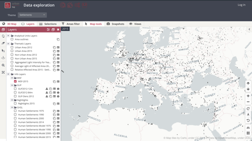
The global map, with its high spatial resolution, is based on a multi-temporal analysis of over 700,000 Copernicus Sentinel-1 radar and Landsat-8 multispectral satellite images, collected during 2014—15.
The new WSF-2015 dataset has been integrated on the U-TEP Visualisation and Analytics Tool, which includes additional data sets such as topographic and social media data, as well as socio-economic statistics, and also gives the user the option of uploading specific geographic information.
Learn More, Read the Complete Post
Direct to Interactive Data Tool/Map
Filed under: Data Files, News
About Gary Price
Gary Price (gprice@gmail.com) is a librarian, writer, consultant, and frequent conference speaker based in the Washington D.C. metro area. He earned his MLIS degree from Wayne State University in Detroit. Price has won several awards including the SLA Innovations in Technology Award and Alumnus of the Year from the Wayne St. University Library and Information Science Program. From 2006-2009 he was Director of Online Information Services at Ask.com.
ADVERTISEMENT
Archives

ADVERTISEMENT