Research Tools: Major Update to Protected Areas Database of the United States
From USGS:
A new version of the Protected Areas Database of the U.S., or PAD-US, has major federal, state and easement updates, an easier-to-use data structure, new web services, national-scale printable maps, and more.
The U.S. Geological Survey announced the release of its Protected Areas Database of the U.S. version 2.0 – a major advance toward the long-term goal of a geospatial inventory that contains every public park and other protected area in America.
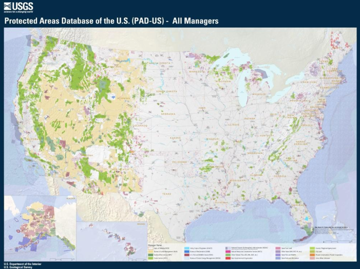
PAD-US is America’s official national inventory of lands held by cities, counties, special park and open-space districts, state parks and preserves as well as national parks and forests, national wildlife refuges, public lands and more. The inventory includes more than 360,000 individual named units, managed by more than 18,000 public agencies and non-governmental organizations, totaling more than 9 billion acres of land and marine areas. It features management designations for conservation and for multiple uses such as forestry, energy, grazing and recreation.
[Clip]
Improvements in version 2.0
The new version of PAD-US features important improvements over the prior version (1.4):
- Changes to the structure of the GIS database to make it easier to use, particularly the separation of feature classes for fee ownership from policy-designated areas (wilderness, national monuments, etc.), plus continuation of layers for easements and marine protected areas.
- A new, separate layer for proclamation and other boundaries that outline forest, park or refuge areas approved for voluntary acquisition and military lands without internal ownership defined.
- Improved boundary line geometry with far fewer overlaps and slivers, particularly among federal fee agency lands.
- Greater consistency and completeness in PAD-US attributes (naming, access, and more).
- New agency reports for data steward contacts and source data links, available soon from the USGS. Current access.
- Updated data from most federal land management agencies (including NPS, USFS, USFWS, BOEM, NOAA and BLM), developed through the Federal Lands Working Group.
- Major updates to more than 30 states, including 12 from the PAD-US State Data-Steward Network (California, Georgia, Iowa, Idaho, Minnesota, Missouri, New Jersey, New York, Oregon, Tennessee, Virginia and West Virginia).
- The integration of nonprofit databases which updated many more states (The Nature Conservancy Fee Lands and Secured Lands aggregation, The Trust for Public Land Conservation Almanac, Ducks Unlimited Conservation and Recreation Lands). More information
- The latest easement data from the National Conservation Easement Database.
- A ready-to-use downloadable statistics table, summarizing PAD-US 1.4 attributes (PAD-US 2.0 update coming soon) by state and for the nation.
- The ability to print map files at any size–including poster size – with four national themes and the states coming soon.
- Updated WMS services for pulling in different views of PAD-US data to applications and desktop GIS sessions.
- A history of PAD-US and a vision for the future of the database. These plans propose the goal of a complete PAD-US by 2020. Currently, approximately 95% of federal lands and waters are included in PAD-US, while only about 60% of state, regional and local park and other preserve lands are in the database. Through the work of the Trust for Public Land’s Park Serve program, great improvements in urban parks data will occur in the next release of PAD-US.
Direct to Complete Announcement
Direct to Protected Areas Database of the U.S. (version 2.0)
- Direct to PAD-US Viewer
Filed under: Associations and Organizations, Data Files, Management and Leadership, Maps, News, Preservation, Reports
About Gary Price
Gary Price (gprice@gmail.com) is a librarian, writer, consultant, and frequent conference speaker based in the Washington D.C. metro area. He earned his MLIS degree from Wayne State University in Detroit. Price has won several awards including the SLA Innovations in Technology Award and Alumnus of the Year from the Wayne St. University Library and Information Science Program. From 2006-2009 he was Director of Online Information Services at Ask.com.
ADVERTISEMENT
Archives

ADVERTISEMENT