Research Tools: NOAA Releases Coastal Inundation Dashboard, New Resource Provides Water Level Data From Over 200 Coastal Stations to Your Desktop
From NOAA:
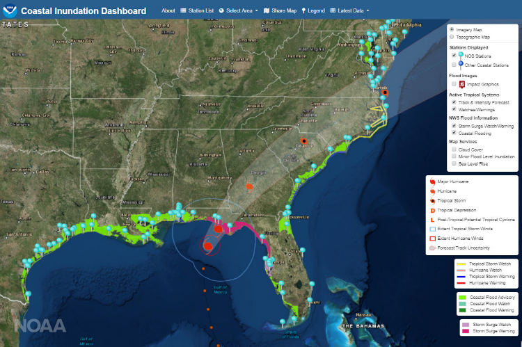
To help people prepare for and manage the effects of coastal flooding, NOAA has brought together data from its over 200 coastal water level stations into one easy-to-use web tool.
The Coastal Inundation Dashboard brings together real-time water level information, 48-hour forecasts of water levels, storm surge and historic flooding information into one online tool to help decision makers as well as coastal residents understand both short-term risks such as an approaching hurricane or nor’easter, as well as longer-term risks like high tide flooding and sea level rise. Boaters and fishermen can even use the tool to get their latest local tides.
[Clip]
The Coastal Inundation Dashboard and QuickLook are brought to you by NOAA’s Center for Operational Oceanographic Products and Services.
Read the Complete Launch Announcement
See Also: New OceanReports Tool Brings Ocean Data To Your Fingertips (April 11, 2019)
Filed under: Dashboards, Data Files, News
About Gary Price
Gary Price (gprice@gmail.com) is a librarian, writer, consultant, and frequent conference speaker based in the Washington D.C. metro area. He earned his MLIS degree from Wayne State University in Detroit. Price has won several awards including the SLA Innovations in Technology Award and Alumnus of the Year from the Wayne St. University Library and Information Science Program. From 2006-2009 he was Director of Online Information Services at Ask.com.
ADVERTISEMENT
Archives

ADVERTISEMENT