Science: Web Resources: New Online Tool From NASA Links Port-City Sea Levels to Regional Ice Melt
From the Jet Propulsion Lab/NASA:
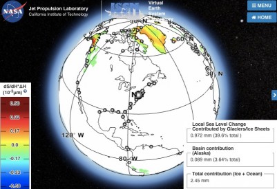
A new NASA tool links changes in sea level in 293 global port cities to specific regions of melting land ice, such as southern Greenland and the Antarctic Peninsula. It is intended to help coastal planners prepare for rising seas in the decades to come.
All coastal cities will see some impacts of global sea level rise. But the new tool shows that, for example, New York City is more strongly affected by melting ice in northeastern Greenland than in southwestern Greenland; while Sydney has a greater risk from the rapidly melting Antarctic Peninsula than from East Antarctica.
A paper describing the new tool, titled “Should coastal planners have concern over where land ice is melting?,” was recently published in the journal Science Advances. The research team is Eric Larour, Erik Ivins and Surendra Adhikari of NASA’s Jet Propulsion Laboratory in Pasadena, California.
Melting ice and rising ocean temperatures contribute about evenly to global sea level rise today. Individual cities are also affected by local conditions such as land sinking. Other Web-based resources such as the U.S. Climate Resilience Toolkit address some of these issues, but the new NASA tool is the only resource to match specific melting ice locations with their effects on the world’s ports.
To calculate this and other influences on sea level such as Earth’s rotation, Larour and his colleagues used a dynamic mathematical formula called the adjoint method, which is used in seismic and meteorological studies. The method enables fast computation of the sensitivity of a model’s output to its inputs — in this case, the sensitivity of sea level to ice melting. They used the method with JPL’s well-tested computer model of ice sheet melting, the Ice Sheet System Model, to develop their new tool, called Gradient Fingerprint Mapping.
Users of the tool need no specialized training or extreme computer power; they simply download it, input data or projections of ice loss, and let it evolve the shifting ice and water patterns forward into the future. The result: a detailed profile of the sensitivity of sea level at any of these cities to changes in ice anywhere in the world.
Among some intriguing results, Larour said, are those for New York, London and Oslo. Greenland’s northeastern ice stream was shown to have an outsized effect on New York’s local sea level, but the island’s southern glaciers had little influence. London was more strongly affected by Greenland’s northwestern and western glaciers. And Norway is so close to Greenland, the island’s gravitational fingerprint is contributing to sea level decrease in Oslo.
[Clip]
The authors note that ocean dynamics can accelerate or offset the changes in sea level from gravitational fingerprints — particularly in New York, where the contribution of melting ice to accelerated sea level rise is minor compared to other sources.
Read the Complete Intro
Direct to New Online Tool From NASA
Filed under: Data Files, Journal Articles, News, Patrons and Users
About Gary Price
Gary Price (gprice@gmail.com) is a librarian, writer, consultant, and frequent conference speaker based in the Washington D.C. metro area. He earned his MLIS degree from Wayne State University in Detroit. Price has won several awards including the SLA Innovations in Technology Award and Alumnus of the Year from the Wayne St. University Library and Information Science Program. From 2006-2009 he was Director of Online Information Services at Ask.com.


