Reference: Article/Data Set: “Yale Researchers Map 6,000 Years of Urban Settlements”
From the Yale School of Forestry and Environmental Studies:
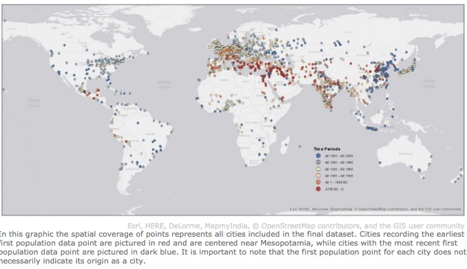
As the growth of cities worldwide transforms humans into an “urban species,” many scholars question the sustainability of modern urbanization. But in reality there aren’t much data on long-term historical urbanization trends and patterns.
A recent Yale-led study offers new clarity on these historical trends, providing the first spatially explicit dataset of the location and size of urban settlements globally over the past 6,000 years.
By creating maps through digitizing, transcribing, and geocoding a deep trove of historical, archaeological, and census-based urban population data previously available only in tabular form, the authors make accessible information on urban centers from 3700 B.C. to A.D. 2000.
[Clip]
Currently the only spatially explicit data available at a global scale is the United Nations World Urbanization Prospects, which provides population values, latitudes, and longitudes for places with populations of 300,000 or more. However, this resource goes back only to 1950.
The ancient Temple of Karnak in present-day Luxor, Egypt (previously the settlement of Thebes, documented in the ancient dataset).
For their dataset, the authors draw on two principle sources: “Four Thousand Years of Urban Growth: A Historical Census” (1987), by historian Tertius Chandler, which estimated the city-level populations from 2250 B.C. to 1975; and “World Cities: -3,000 to 2,000” (2003), by political scientist George Modelski, which documents the world’s most important cities during three eras of history (ancient, classical, and modern). Modelski was able to extend Chandler’s work by 1,475 years by using archaeological site assessments and population-density estimates.
Read the Complete Summary
Direct to Full Text Article and Downloadable Dataset (Open): “Spatializing 6,000 years of global urbanization from 3700 BC to AD 2000” (via Scientific Data 3, Article number: 160034 (2016))
Filed under: Data Files, Maps, News
About Gary Price
Gary Price (gprice@gmail.com) is a librarian, writer, consultant, and frequent conference speaker based in the Washington D.C. metro area. He earned his MLIS degree from Wayne State University in Detroit. Price has won several awards including the SLA Innovations in Technology Award and Alumnus of the Year from the Wayne St. University Library and Information Science Program. From 2006-2009 he was Director of Online Information Services at Ask.com.
ADVERTISEMENT
Archives

ADVERTISEMENT