SUBSCRIBE
SUBSCRIBE
EXPLORE +
  • About infoDOCKET
  • Academic Libraries on LJ
  • Research on LJ
  • News on LJ
  • Skip to primary navigation
  • Skip to main content
  • Skip to primary sidebar
  • Libraries
    • Academic Libraries
    • Government Libraries
    • National Libraries
    • Public Libraries
  • Companies (Publishers/Vendors)
    • EBSCO
    • Elsevier
    • Ex Libris
    • Frontiers
    • Gale
    • PLOS
    • Scholastic
  • New Resources
    • Dashboards
    • Data Files
    • Digital Collections
    • Digital Preservation
    • Interactive Tools
    • Maps
    • Other
    • Podcasts
    • Productivity
  • New Research
    • Conference Presentations
    • Journal Articles
    • Lecture
    • New Issue
    • Reports
  • Topics
    • Archives & Special Collections
    • Associations & Organizations
    • Awards
    • Funding
    • Interviews
    • Jobs
    • Management & Leadership
    • News
    • Patrons & Users
    • Preservation
    • Profiles
    • Publishing
    • Roundup
    • Scholarly Communications
      • Open Access

October 7, 2013 by Gary Price

Amtrak Now Provides Real-Time Train Tracking Map For Entire Country
October 7, 2013 by Gary Price

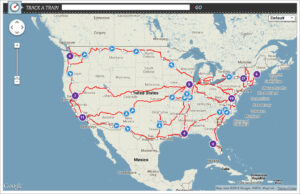
Last week Amtrak (in conjunction with Google) launched a new interactive map that allows users to see, in real-time, where a specific train or trains are located at that moment across the entire system.
Using the map is nothing different than what you’re used to with other map services that are powered by Google including an option to toggle between a road map or satellite imagery.
Select a specific train by clicking on a blue arrow icon and you’ll be provided with train status, last update time, direction the train is heading, speed, scheduled arrival times, and delay info.Click the “detailed train status” link for more info.
You can also search for specific station or by train name .
To access the map look for a link on many Amtrak web pages or by clicking the train tracking map banner at the top of this page.
For the time being this direct link to the Amtrak map is also working.
See Also: The Real-Time and Historic Amtrak Tracking Database (StatusMaps.net) via Dixieland Software Remains Online
StatusMaps also provides alerts to inform users about delays. It’s also a free service.
See Also: One on One With Google Maps Engine (via Amtrak Blog)

Filed under: Maps, News, Patrons and Users

SHARE:

About Gary Price

Gary Price (gprice@mediasourceinc.com) is a librarian, writer, consultant, and frequent conference speaker based in the Washington D.C. metro area. Before launching INFOdocket, Price and Shirl Kennedy were the founders and senior editors at ResourceShelf and DocuTicker for 10 years. From 2006-2009 he was Director of Online Information Services at Ask.com, and is currently a contributing editor at Search Engine Land.

ADVERTISEMENT

Archives

Job Zone

ADVERTISEMENT

Recent Articles on LJ

From the Top: Library Leaders Talk EDI | Equity

After the MLIS

Dartmouth Repatriates Samson Occom Papers to Mohegan Tribe

Tour de France: A Watching, Reading, and Listening Guide | Your Home Librarian

On Critical Cataloging: Q&A with Treshani Perera | Equity

ADVERTISEMENT

Related Infodocket Posts

Dynamic World: A New Online Tool from World Resources Institute and Google Earth Engine Shows How the Planet...

From Fast Company: A new tool from Google Earth Engine and the nonprofit World Resources Institute pulls from satellite data to build detailed maps in near real time. Called Dynamic ...

New “Lost Voices” Online Exhibit Translates and Digitizes America’s Oldest Parish Archive to Provide Rare Insight Into Early...

From the University of South Florida: A new online exhibit launched today by La Florida: The Interactive Digital Archives of the Americas will provide the public with unprecedented insight into ...

Research Tools: NOAA Launches New Online Mapping Tool to Better Track the Location and Movement of Marine Fish...

From NOAA: NOAA Fisheries is launching a new tool to better track the location and movement of marine fish in U.S. waters. The Distribution Mapping and Analysis Portal reveals that ...

Research Resources: National Archives (NARA) Releases 1950 U.S Census Online

From NARA: Taken every 10 years since 1790, the United States census provides a snapshot of the nation’s population. Because of a 72-year restriction on access to the records, the ...

Research Tools: Historic England Launches New Map Revealing a Century of England From the Air, Over 100 Years...

From Historic England: Today, Historic England launches its new Aerial Photography Explorer – which for the first time allows users to search and explore an online map showing aerial photographs ...

Research Tools: National Broadband Availability Map Reaches 40 State, U.S. Territory Participants

From the NTIA: Over the last few months, NTIA’s National Broadband Availability Map (NBAM) has added Nevada, Louisiana, American Samoa, and Puerto Rico to its growing roster of participants. To ...

NARA: 1950 Census Release Will Offer Enhanced Digital Access, Public Collaboration Opportunity

From the National Archives and Records Administration: With the scheduled April 1, 2022, release of 1950 Census records a little more than three months away, the National Archives is completing ...

A New Issue of Weave: Journal of Library User Experience (Vol. 4 No. 2) is Now Available Online

Weave: Journal of Library User Experience (Vol. 4 No. 2) Includes the Following Peer-Reviewed Articles: Using UX Personas to Improve Library GIS and Data Services by Taylor Hixson and Justin ...

NOAA Releases a Redesigned Climate.gov Website

From NOAA: NOAA’s Climate Program Office today launched a newly redesigned version of Climate.gov, NOAA’s award-winning, flagship website that provides the public with clear, timely, and science-based information about climate. ...

Research Tools: New UN Tool Maps Floods Since 1985 To Street Level, Will Aid Disaster Planning, Especially in...

From the United Nations University: UN University-led experts have debuted a new tool that generates instant, accurate street-level resolution maps of floods worldwide since 1985. The free online World Flood ...

Apple Maps Introduces New Ways to Explore Major Cities in 3D; Now Available For London, Los Angeles, New...

From Apple: With the release of iOS 15, Apple Maps gets its biggest update ever with a city experience that offers rich details, driving routes with better navigation, immersive walking ...

Research Resources: "New Health Equity Tool Tracks How the Pandemic is Affecting Communities"

From the Annie E. Casey Foundation: Called Health Equity Tracker, the new tool is designed to aid policymakers and leaders in identifying existing racial health inequities so that they can ...

ADVERTISEMENT

FOLLOW INFODOCKET ON TWITTER

Tweets by @infodocket

ADVERTISEMENT

This coverage is free for all visitors. Your support makes this possible.

This coverage is free for all visitors. Your support makes this possible.

Primary Sidebar

  • News
  • Reviews+
  • Technology
  • Programs+
  • Design
  • Leadership
  • People
  • COVID-19
  • Advocacy
  • Opinion
  • INFOdocket
  • Job Zone

Reviews+

  • Booklists
  • Prepub Alert
  • Book Pulse
  • Media
  • Readers' Advisory
  • Self-Published Books
  • Review Submissions
  • Review for LJ

Awards

  • Library of the Year
  • Librarian of the Year
  • Movers & Shakers 2022
  • Paralibrarian of the Year
  • Best Small Library
  • Marketer of the Year
  • All Awards Guidelines
  • Community Impact Prize

Resources

  • LJ Index/Star Libraries
  • Research
  • White Papers / Case Studies

Events & PD

  • Online Courses
  • In-Person Events
  • Virtual Events
  • Webcasts
  • About Us
  • Contact Us
  • Advertise
  • Subscribe
  • Media Inquiries
  • Newsletter Sign Up
  • Submit Features/News
  • Data Privacy
  • Terms of Use
  • Terms of Sale
  • FAQs
  • Careers at MSI


© 2022 Library Journal. All rights reserved.


© 2022 Library Journal. All rights reserved.