Research Tools: New UN Tool Maps Floods Since 1985 To Street Level, Will Aid Disaster Planning, Especially in Global South
From the United Nations University:
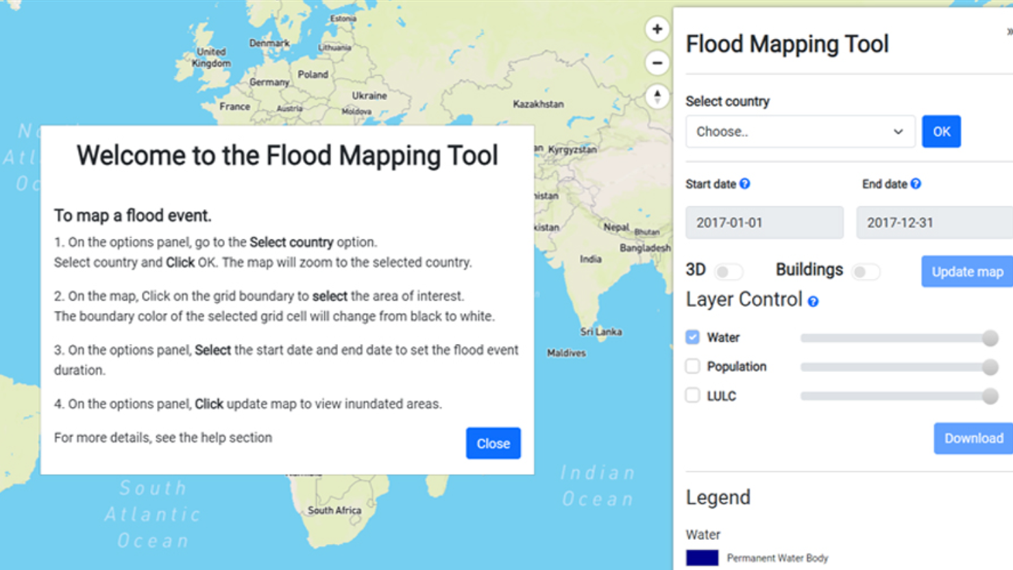
UN University-led experts have debuted a new tool that generates instant, accurate street-level resolution maps of floods worldwide since 1985. The free online World Flood Mapping Tool will help all countries but especially those in the Global South, where flood risk maps are rare and often badly out of date.
Created by the UN University’s Institute for Water, Environment and Health in Hamilton, Canada, with support from Google, MapBox and other partners listed below, the tool lets users adjust variables to help locate gaps in flood defences and responses, and to plan future development of all kinds — for example, where to build or upgrade infrastructure, or develop agriculture.
Simple to use, the tool, at https://floodmapping.inweh.unu.edu, requires only Internet access to obtain a flood map at 30-meter resolution — street by street level. An upcoming version for more commercial uses, for example by insurance firms, will offer even more precise building-level resolution.
The tool allows users to adjust variables to help locate gaps in flood defences and responses, and to plan future development of all kinds — for example, where to build or upgrade infrastructure, or develop agriculture.
[Clip]
The World Flood Mapping Tool uses the Google Earth Engine combined with decades of Landsat data since 1985 — a vast catalog of geospatial data enabling planet-scale analysis capabilities.
Layers of Landsat information for a selected region and specified timeframe identifies temporary and permanent water bodies while integrating site-specific elevation and land-use data.
This produces a detailed map of flood inundation in recent decades, with available overlays of population, buildings and land use, which can be used for community planning, building zoning, insurance assessments and more.
[Clip]
It differs from previously available systems in a number of ways, including:
-Improved resolution of inundation maps to 30 meter resolution, enabling analysis at a citywide level
-Focus on the Global South, where data and information gaps are prominent and annual losses due to floods are high
-Improved accuracy of inundation maps using data from multiple satellite sensors
-Improved accuracy and shorter development time of flood risk maps by using AI models
Learn More, Read the Complete Launch Announcement
Direct to New Flood Mapping Tool
Filed under: Data Files, Maps, News, Patrons and Users
About Gary Price
Gary Price (gprice@gmail.com) is a librarian, writer, consultant, and frequent conference speaker based in the Washington D.C. metro area. He earned his MLIS degree from Wayne State University in Detroit. Price has won several awards including the SLA Innovations in Technology Award and Alumnus of the Year from the Wayne St. University Library and Information Science Program. From 2006-2009 he was Director of Online Information Services at Ask.com.
ADVERTISEMENT
Archives

ADVERTISEMENT