New From the David Rumsey Map Collection: “Early Mapping of Silicon Valley and the Web”
From the David Rumsey Map Collection:
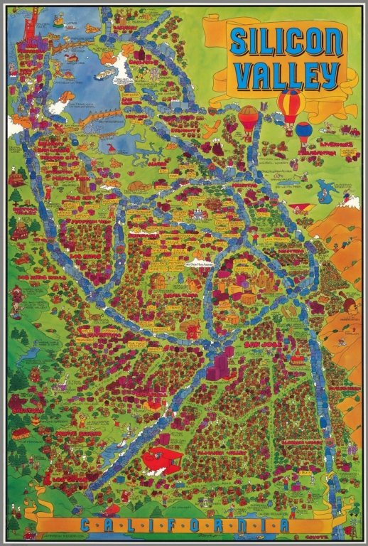
Five pictorial maps…trace the development of Silicon Valley from 1981 to 1991. Six additional maps show the growth of the Web from 1995 to 2009. There are interesting commonalities between the maps, the first group of five showing the physical space of Silicon Valley in the 1980’s and the location of its first start up companies, many now gone. The six Web maps are an abstraction of the invisible structure of the early 1995 Web, leading to the complexity of the Web of 2009.
Below is the earliest map we have seen to identify Silicon Valley and show the businesses there, although it is likely there may be earlier ones. Published in 1981, it shows the San Francisco Bay area from San Francisco south to Almaden Valley. The graphic method is typical for pictorial maps of the period, using a cartoon style and bright colors. It was drawn by children’s book illustrator Corbin Hillam.
Direct to Complete Post/View All Maps
About Gary Price
Gary Price (gprice@gmail.com) is a librarian, writer, consultant, and frequent conference speaker based in the Washington D.C. metro area. He earned his MLIS degree from Wayne State University in Detroit. Price has won several awards including the SLA Innovations in Technology Award and Alumnus of the Year from the Wayne St. University Library and Information Science Program. From 2006-2009 he was Director of Online Information Services at Ask.com.
ADVERTISEMENT
Archives

ADVERTISEMENT