Earlier this month, the USGS launched “TopoView 2.1”, an enhancement to the current popular TopoView mapping service that lets users discover, interact, and download historical USGS topographic maps scans.
TopoView 2.1 is a modern web application built on an open source mapping platform that is free of charge. The highly interactive service provides tools and procedures that allow users to easily find historic map scans from USGS’s Historical Topographic Map Collection and even compare those with modern day maps.
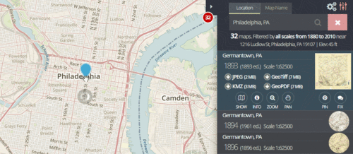
Comparing modern-day Philadelphia to the historical map of the area in 1891. TopoView lets users easily visualize changes to areas that were mapped by the USGS throughout history. (via USGS)
Upgraded features include:
new user interface that’s faster and easier to use,
access and download maps from a variety of search terms
intuitive tools to compare historical maps with maps of the present.
ability to preview maps within the interface
filters and searches that work seamlessly with the map records table to get you the info you want with just a few clicks.
To further assist users with these features, the TopoView team has released a “how to” video to walk through the download and comparison process.
TopoView highlights one of the USGS’s most important and useful products, the topographic map. In 1879, the USGS began to map the Nation’s topography.
The most current maps are available from The National Map and US Topo quadrangles. TopoView shows the many and varied older maps of each area, and so is useful for historical purposes—for example, the names of some natural and cultural features have changed over time, and the ‘old’ names can be found on these historical topographic maps.
Gary Price (gprice@gmail.com) is a librarian, writer, consultant, and frequent conference speaker based in the Washington D.C. metro area.
He earned his MLIS degree from Wayne State University in Detroit.
Price has won several awards including the SLA Innovations in Technology Award and Alumnus of the Year from the Wayne St. University Library and Information Science Program. From 2006-2009 he was Director of Online Information Services at Ask.com.