Reference: NASA Total Solar Eclipse Press Kit and Other Eclipse Resources
Live Coverage via NASA TV
UPDATE August 20: Precision Eclipse Computation Database (“What to Expect” at Any Location; via Wolfram|Alpha)
UPDATE August 19: The Best—and Quirkiest—Maps of the 2017 Solar Eclipse (via National Geographic)
UPDATE August 18: Eclipse Will Have Atmospheric Impact (via NCEI)
UPDATE August 17: Links to Eclipse Apps From the Smithsonian, Exploratorium, Jet Propulsion Laboratory, and Others
UPDATE August 14: NASA Announces Television Coverage for Aug. 21 Solar Eclipse
UPDATE August 10: NASA Provides Tips For Photographing the Total Solar Eclipse ||| Additional Eclipse Photography Tips, Resources, and Images
- This NASA press kit (40 pages; PDF) is loaded with useful information about the upcoming solar eclipse.
Here’s a look at the Table of Contents:
Direct to Full Text Media Kit
Additional Resources
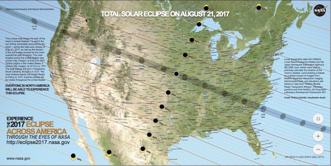
Downloadable Eclipse Resources From NASA
Including maps, fact sheets, info card, and more.
Emergency Management: Solar Eclipses: Planning Resources (via TRACIE)
Transportation: 2017 Solar Eclipse Transportation Fact Sheet for State and Local Departments of Transportation (via FHWA)
Transportation: National Operations Center of Excellence Nationwide Solar Eclipse
Weather: The Great American Solar Eclipse of August 21, 2017 (via National Weather Service)
See Also: NASA Eyes (An Interactive 3D Eclipse Simulator)
See Also: Eclipse Animations (via Rice University)
Filed under: Libraries, Management and Leadership, Maps, News
About Gary Price
Gary Price (gprice@gmail.com) is a librarian, writer, consultant, and frequent conference speaker based in the Washington D.C. metro area. He earned his MLIS degree from Wayne State University in Detroit. Price has won several awards including the SLA Innovations in Technology Award and Alumnus of the Year from the Wayne St. University Library and Information Science Program. From 2006-2009 he was Director of Online Information Services at Ask.com.
ADVERTISEMENT
Archives

ADVERTISEMENT